
DAY WALKS: FORESTS EAST OF MELBOURNE
The ash forests east of Melbourne cover a huge area from Healesville and Warburton in the west to the Baw Baw Plateau and Walhalla in the east. They supply the city with water, timber and even electricity.
The rolling hills and mountains contain an astonishing diversity of habitats; each offers a different experience for the walker: from the semi-urban Dandenong Ranges to windswept sub-alpine woodland to viewing elegant Woollybutts through a ferny understory to the overwhelming stands of mountain ash (the tallest hardwood in the world) and of course, the cool temperate rainforest with it's myrtle beech and sassafras trees.
There are dozens of great walks in this region. Here are a few favourites that aren't included in recent guidebooks.
Walks on this page:

The Rain Forest Gallery walk at the Donna Buang turn off.
Walks on Mt. Donna Buang.
© David Sisson, 2007 - 2015.
Background. Mt Donna Buang (1250 metres) is the nearest snowfield to Melbourne. After the completion of the railway to Warburton in 1901 the tall ash forests on it's slopes were harvested in the early 20th century and the timber was moved to sawmills by a network of tramlines and cable haulages. Logging had finished by the early 1920's and interest in skiing took off in the mid 1920's. Before the Second World War, Donna was a major ski resort with six cleared runs, a ski jump, cafes, a ski hire and several ski lodges. On one day in 1935 12,000 watched ski races on Donna. However the ski runs were fairly short and the snow was never terribly reliable and after the Second World War, skiers deserted it in favour of more reliable snow on higher mountains further aay from Melbourne.
Today most of the mountain is parkland. It is a accessed by a sealed road and is a popular tourist destination. In winter it attracts sightseers who play in the snow. There is a 21 metre high lookout tower on the summit accessed by a strange double helix staircase. From the top there are impressive views of mountains and forests, as well as the farmland and towns of the Yarra Valley. While you can drive to the top, there are a number of walking tracks up the mountain. One is a long day hike from Dom Dom Saddle, another begins at the aptly named Martyr Road in Warburton while a third starts half way up, near the Cement Creek Rainforest Gallery. There is also an easier option of a scenic walk from the Ten Mile Turntable near the summit.
Walks on Mt. Donna Buang.
Ten Mile Turntable, summit circuit and Mt Victoria. . Medium. . 3½ hours. 8? km. . . . . . . . . . . . . . . . GREEN on the map.
Cement Creek, rainforest and Mt Victoria. . . . . . Medium - Hard. . . 4 hrs. 5 for circuit. . 8 / 13 km. . . BLUE on the map.
Warburton to Summit. . . . . . . . . . . . . . . . . . . . . . . . Hard. . 4 hrs, 6½ return. 7 km, 13 km return. . . . . PINK on the map.

Donna Buang summit. This is the third tower on the site.© David Sisson 2007.
Ten mile turntable, summit circuit and Mt Victoria.
Shown in GREEN on the map.
Time and distance: 3½ hours, 8 km. Grade: Medium. Along with the Rainforest Gallery at the junction of the Acheron Way and the Donna Buang Road, this walk covers the best of Mt Donna Buang. The first half hour has some mildly steep sections, although they should not be too much bother if you take a few rests.
Access. Drive through Warburton until the highway, B 380, crosses the Yarra River. Shortly afterwards turn left onto The Acheron Way, C 507. The road climbs steadily for 7 km to the Cement Creek junction. Park here and spend 15 minutes inspecting the impressive Rainforest Gallery, a 350 metre walking circuit that starts high in the forest canopy before descending to the forest floor. Then drive up the Donna Buang Road, C 505, for 6 km to the 10 Mile picnic area and park. This pleasant location is much nicer and less crowded than the rather bleak car parks closer to the summit.
The walk. Leave your car at the large car park at the 10 mile turntable and walk back down the road for 20 metres. There you will see a track heading up hill with a couple of posts to prevent vehicle access. Walk up this track which climbs through mountain ash and tree ferns for 400 metres to a signposted junction. Turn left and continue uphill, through mixed beech and ash forest, past a ruined ski lodge, for another 600 metres to the treeless summit area. In addition to the 21 metre high observation tower, there are picnic tables, a toilet block and a large but basic shelter hut without doors. The view from the tower is breathtaking. On a clear day there are endless forested mountains in most directions, while to the west, Melbourne's office towers are visible on a clear day.

Ruined ski lodge on Donna Buang. © David Sisson 2007
After a break, walk to the north of tower and locate a track that descends to the north-east. It follows an old ski run from the days when Donna was a ski resort. At the bottom of the ski run, the track continues through a forest of myrtle beech before intersecting with a well maintained gravel road. Turn hard left and walk south along the road for 1 km until you reach a gate. Walk around the gate and soon you will meet the sealed road that provides access to the summit area. Turn left and head up the road for a short distance before taking an earth road that branches off to the right. This road crosses through three more former ski runs (one is still used as a toboggan slope), before it becomes a walking track that heads through bush for a few hundred metres before joining the track you originally climbed to the summit.
Head down the track for about 400 metres to the junction where you have a choice. You can end the walk by turning right and walking 400 metres to the 10 mile car park. If you wish to extend the walk by an hour to Mt Victoria, stay on the track along the ridge top, The route undulates through attractive mixed species forest to Mt Victoria, (which is barely a knoll), before descending to a telephone tower. Then walk down a gravel road for 500 metres to the main sealed road, turn right and walk 800 metres up the road to the 10 Mile picnic area.
Last walked in August 2014. All tracks were in good condition. © David Sisson 2009 - 2015.
Donna Buang via Cement Creek, rainforest and Mt Victoria.
Shown in BLUE on the map.
Note: In 2009 Parks Victoria officially closed the section of this walk that parallels Cement Creek without explanation. So while it remains one of the best hikes in the state, it has not been maintained for six years and the lower 1 km near where the track crosses Cement Creek has become overgrown and navigation is rather difficult. The last time I walked it, we lost the track twice in this section, so stay alert and don't be afraid to back track a little. Elsewhere the track remains in fairly good condition, although the occasional tree has fallen across it.
Time and distance: 4+ hours, 8 km. Grade: Medium to Hard grade, suitable for a reasonably fit group. Add an hour if you will be walking the last 4½ km down the road rather than driving back to the start.
This is the most attractive walk in the Warburton area and is mostly through cool temperate rainforest. So while it involves a 750 metre climb, it is well worth the effort. Most of the walk is moderately graded except for the overgrown and difficult to navigate section at the start and two short but fairly steep sections later in the walk. If it has rained or there is snow on the ground, there will be water on the track for the first kilometre and it may be difficult to keep your feet dry, so carry a spare pair of dry socks.
Access. From Melbourne drive to Lilydale and follow the Warburton Highway B 380 through Warburton to where the road crosses the Yarra River. Shortly afterwards turn left on to The Acheron Way, C 507. The road immediately begins a steady climb which continues for 7 km to the Cement Creek junction. Park here and spend 15 minutes inspecting the impressive Rainforest Gallery, a 350 metre walking circuit that starts high in the forest canopy before descending to the forest floor.
The Cement Creek walking track starts 250 metres along the Donna Buang road. You can either walk from the Rainforest Gallery or drive up and park in the large clearing at the start of the track on the left of the road.
The ascent via Cement Creek and Boobyalla Saddle.
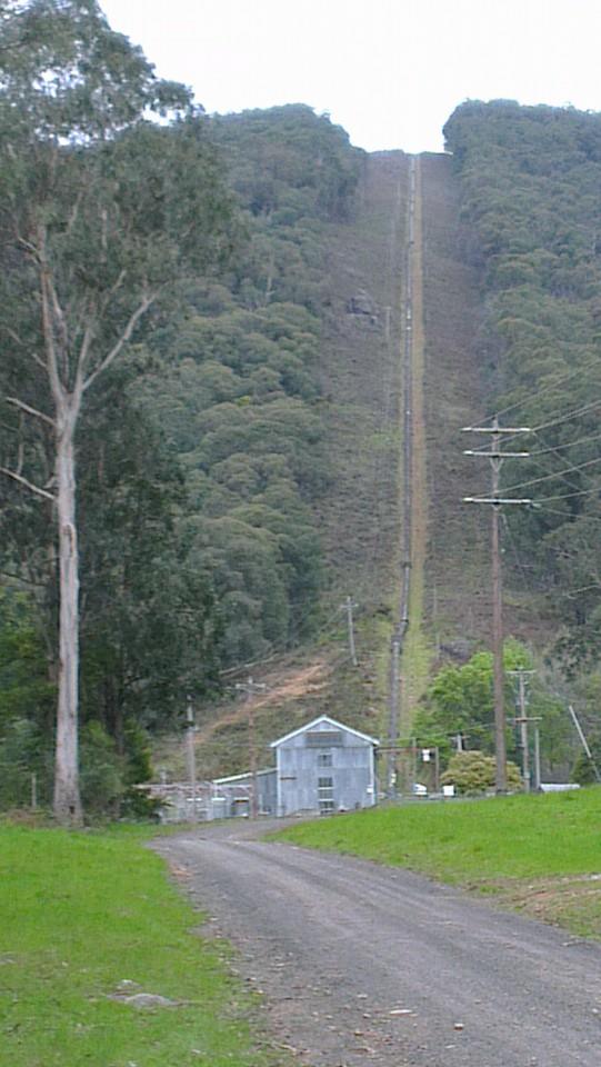
The track immediately plunges into tall eucalypt forest where it has become overgrown since Parks Victoria ceased maintenance in 2009. The route is not always obvious, but it crosses Cement Creek and some tributaries by a combination of bridges and stepping stones. If it has rained recently or there is snow on the ground, the first 1½ km can be quite wet and muddy with water running down the track. Eventually the route emerges from the creek valley and the track becomes more obvious as it begins to climb the hillside on the north side of the creek. This is actually an old cable haulage tramline where logs were winched down the mountain. There are a few diversions where trees have fallen over the track, but it essentially continues in a fairly straight line parallel to the creek. This is the steepest part of the walk, so take a few breaks and look around at the forest. Below the towering Mountain Ash canopy, you will see a rainforest understory of Tree Ferns, Sassafras, Mountain Hickory Wattle and Myrtle Beech.
Soon the old cable haulage finishes and you emerge onto a flat section where the tramway was horse drawn before the climb resumes for a short distance. Soon after the end of this second climb, the scenery changes from rainforest with a Mountain Ash overstory to more open Woollybutt (or Alpine Ash) woodland. Follow the track through the tall trees and just as they are changing to Snowgums, you will arrive at a track junction at Boobyalla Saddle.

1950's sign north of the summit. © David Sisson 2007
Take a breather before the final section to the summit. Turn left and head south along an undulating track. There is an especially attractive spot where the track passes through a pure stand of Myrtle Beech. Before long, it joins a Melbourne Water road. Turn left and continue south for 250 metres until a dip in the road which usually features a large puddle. Just as the road starts to climb, take a track to the left heading into the forest. There is a short climb up a former ski run through beech and eucalypts and soon you will emerge at the the summit.
The summit boasts an impressive 21 metre high lookout tower with a curious double helix staircase. The view from the top is spectacular. Nearby is a slightly squalid shelter hut with partially open sides and a toilet block. At busy times in winter, there may be a caravan selling snacks.
The descent via Mt Victoria. From the observation tower, walk 100 metres east towards the toilet block. Contour north across the top of a fenced off former ski run. Soon you will pick up a good track that heads downhill, roughly paralleling the fence line. In snow the route is fairly clear and it is marked with occasional red metal arrows. Just past the bottom of the ski run is the ruin of an old ski lodge.
Soon you will reach a junction with a track to the right heading south to Ten Mile picnic area. Take the left hand track which stays on the top of the ridge and remains fairly level for 2 km to Mt Victoria. The 'summit' is barely perceptible as it is really a knoll on a spur that looks like a mountain from near Warburton. The track then descends to a telephone tower. From here there is a short section of gravel road before the main sealed Donna Buang Road. If you have left a car here, drive down to the start of the walking track, otherwise it is an easy hour's walk along the road to your cars.

Cement Creek track under snow. © David Sisson 2007.
Winter. The Cement Creek walk is especially attractive for experienced groups in winter, although heavy snow in July and August may make things a little harder. However walking through a silent beech forest in deep snow is a truly wonderful experience and rare outside Tasmania. Everyone in the group should have a good quality raincoat that won't tear on scrub as well as overpants, gloves, a warm hat, telephone, food and a spare pair of warm, dry socks. The snow can be quite soft and deep, so if it has snowed before your walk, it might be useful if at least one person in the group has snowshoes to help pack down the track.
At most there should be only light snow over the scrubby and navigationally tricky section at the bottom of the walk. While you should have a GPS, staying on the track in snow isn't too much of a problem on most of the route except for the top section of the track paralleling Cement Creek before Boobyalla Saddle. Having a GPS with the track shown on the map will help in this regard. Keep an eye out for the markers nailed to trees on this section. They are more easily seen looking downhill, so make sure you turn around frequently so as to stay on the track.
Warbuton to Donna Buang via Mt Victoria.
Shown in PINK on the map.
Time and distance: 6+ hours, 14 km. Grade: Hard.
If you're up to it, it's very satisfying to climb the mountain right from the bottom. This walk is a bit of a 'hero hike' for people training for long trips. The 1,100 metre ascent is long and steep, (the only steeper walk nearby is the track up Mt Juliet). While it is all on reasonable tracks, the walk is rated medium-hard. Fit people should be able to do the 7 km climb in 4 hours, while the downhill return by almost the same route will take about 2½ hours.
Access. From Melbourne drive along the Warburton Highway, B 380, to Warburton. As you enter the town, turn left on to a bridge which crosses the Yarra River. (Melways 289 K4) Immediately turn right along Dammans Road and take the first turn to the left onto Martyr Road. Drive to the top of this very steep road next to the golf course and park at the corner where the road turns right and becomes Wellington Road.
The walk. From the car park at the the top of Martyr Road, the track initially drops down through forest to a creek before heading north along a fence line next to a paddock. At the top of the paddock, the track turns east for a short distance before heading into forest for a minute to meet a disused aqueduct. Cross the aqueduct and keep climbing. The track unrelentingly heads straight up the mountain, mostly through Mountain Ash forest. 4 km from the start of the walk, cross the sealed Donna Buang Road and continue up a gravel road to a phone tower. At the end of road, continue along a well defined walking track. After 500 metres you will get to the rather flat top of Mt Victoria and the climbing ends! The next 2 km are gently undulating. At a junction, ignore the track heading south to 10 Mile car park and head north west towards the final 600 metre climb to the summit. If you still have the energy, it is worthwhile to climb the 21 metre observation tower.
If you haven't arranged a lift down, have a rest and go back the way you came, diverting via 10 mile and a short walk on the sealed road.
If you want to have an especially long and epic day, take the old Cement Creek track down to the road junction and then walk down the Acheron Way towards Warburton for just over 3 km to where it crosses the aqueduct. Leave the road and head west along the aqueduct walking track until you come to the well signposted track back to the top of Martyr Road. Retrace the first 500 metres of the day's walk downhill to where you left your car.
© David Sisson.

Beech Creek trestle bridge. © David Sisson 2013
RUBICON AQUEDUCTS
A rather pretty walk with no steep hills... unless you choose the harder option. Don't let the hydro power stations and tram lines put you off, this is a nature walk with a bit of history, not an industrial walk. The full walk should take about 5 hours, while it's about 18 km, it's mostly flat and entirely on good tracks, so you will walk faster than usual.
Royston Power Station of the Rubicon Aqueduct. © David Sisson 2013
Access
From Melbourne, drive to Healesville and continue on the Maroondah Highway B 360 over the Black Spur. The outdoor shop in Narbethong stocks maps of the area and hiking gear. Continue to the hamlet of Taggerty and turn right on to the road leading to Eildon C 515. Continue for 9 km to the bridge over the Rubicon River. Avoid 'crossing the Rubicon', instead turn right onto the Rubicon Road. The first 5 km is sealed, but the last 3 km are gravel. Just before you get to the power station with the huge pipeline, turn left onto the Royston River Road and climb for 5 km to the junction with Le Bruns Road. It is on the edge of a coupe where recovery logging took place after the 2009 fires. Park your car here.

Old mini sawmill, Rubicon Aqueduct tramway. © David Sisson 2013
The walk
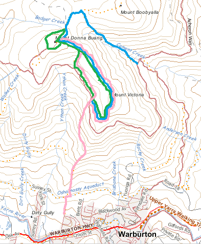
Walk south along the Royston River Road for 2 km until you get to a road junction. Turn right and head downhill parallel to the wood stave pipeline that leads to the pretty Royston Power Station.
Continue south along the tramline for 3.4 km to the Rubicon Dam. This side trip winds it's way through attractive tall forest on a flat route. There are a couple of scenic bridges, Beech Creek trestle was toasted in the 2009 fire and has been rebuilt, (sadly without tramlines). The Lubra Creek Trestle has a rotten deck with gaps of a couple of metres that are undecked, so descend a side track to the creek to get across the valley. At the end of the tramline take in the atmosphere of the damp gorge and it's small dam. The steep stairway to the top of the dam wall has a locked gate, but with a little clambering, it is possible to get around the gate. The view of both the lake and valley from the dam wall is well worth the extra effort. After a break, return to Royston power station.
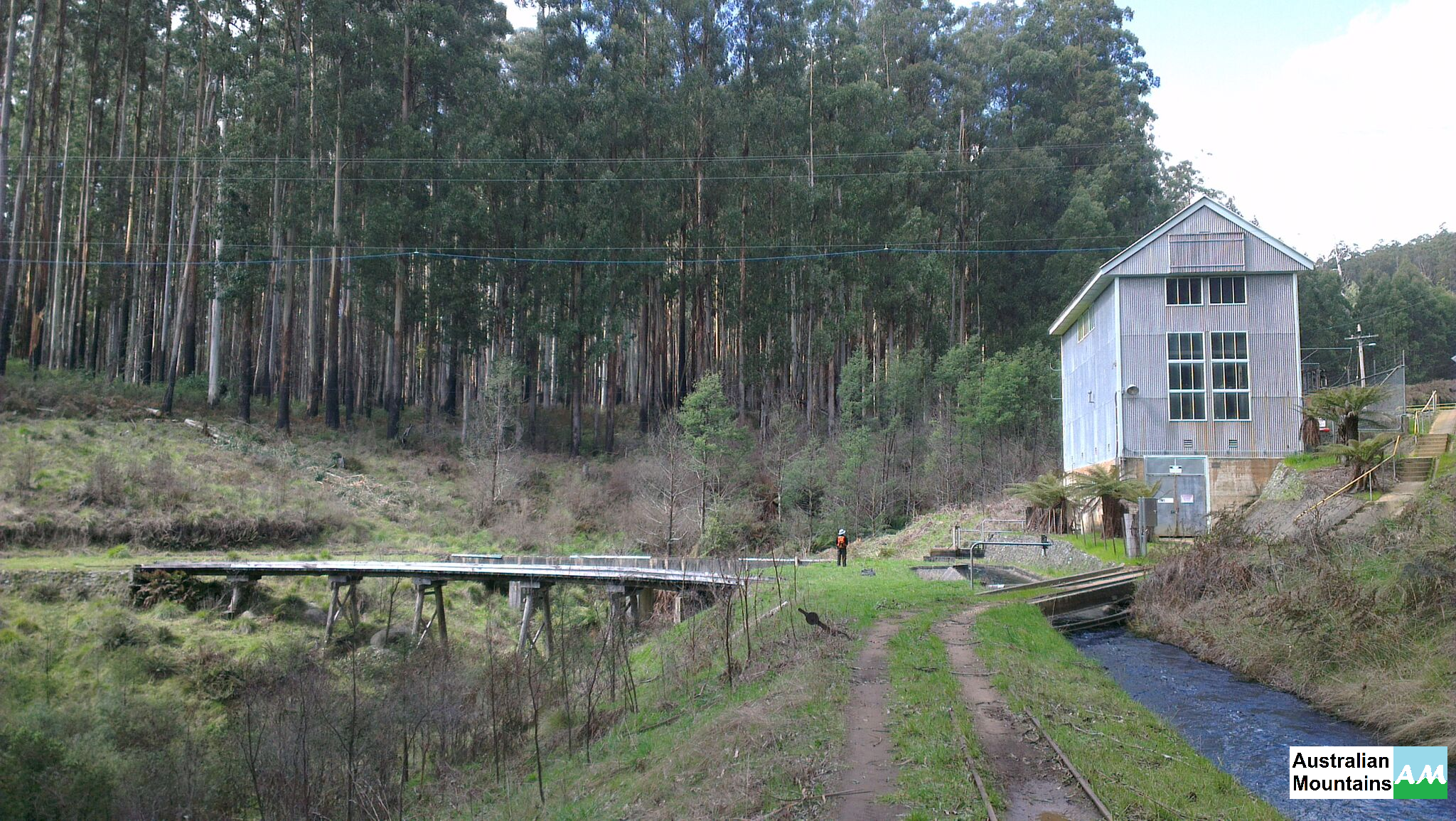
At Royston power station head north on the tramline beside the aqueduct, walking past a mini sawmill and a house. Soon afterwards the line crosses a road on another trestle bridge. Either walk over the bridge or descend and walk to the other end of the bridge, but don't be tempted to take a minor road that starts off running parallel to the aqueduct. This road has lots of ups and downs. Instead climb back up to the tramline and walk north beside the aqueduct for 5 km until you get to the forebay at the end of the aqueduct. There was once a small village here with a dozen or so houses. There are still four buildings including a shed for the rail vehicles and a building that houses the huge winch that once hauled passengers and freight up the steep incline. Take in the stunning view from the forebay. This is the place where the open aqueduct feeds into a steep penstock taking the water down to Rubicon power station 450 metres below. You can see the Goulburn Valley and lots more too.
Rubicon power station and penstock. © David Sisson 2013.
After taking in the view, walk south east up Le Bruns Road for 3km to your car.
Variations
- The side trip from Royston Power Station to the Rubicon Dam is probably the most attractive part of the walk, but it is optional. You can save 7 km of walking and one and a half hours if you omit it.
- A harder option is to start the walk at Rubicon Power Station at the bottom of the huge pipeline. Walk up Rubicon Road past the tiny Rubicon Falls power station to join the walk described above near Royston Power station. It's worth doing the great side trip to the Rubicon Dam. (Marked in dark blue on the map.) Then head north up the tramline (not the undulating road which initially runs parallel to it) to the end of the aqueduct. At the Winch House at the northern end of the aqueduct, walk down the very steep haulage tramline. It's a rough 1.3 km at a gradient of 1 in 3. So while it's a rather exciting way to descend to your car, your knees and ankles may never forgive you.
If you want to discover more about the fascinating history of the area with it's tramways, timber harvesting and hydro electricity, have a look at: Peter Evans. Rails to Rubicon: a history of the Rubicon forest. Light Railway Research Society of Australia, 1994.
© David Sisson 2012 - 2013.

MT TORBRECK
Mt Torbreck is a 1516 metre high rocky mountain half way between Marysville and Eildon. It is the westernmost mountain in the high country over 1500 metres and was briefly a designated ski resort in the 1980's, although the only infrastructure built was a picnic table.
Time, distance and grade.
The 7 km return trip climbs 600 metres and should take about 4 hours including a few breaks. If you have plenty of time to take it easy on the steep section, the walk is rated medium.
Access.
From Melbourne head to Lilydale and continue on to Healesville on the Maroondah Highway B 360. Follow the highway over the Black Spur and on to the small town of Taggerty. Turn left and take the C 515 to Thornton. Then follow the Goulburn Valley Highway B 340 to the Snobs Creek pub (aka Eildon Holiday Resort Hotel), 5 km before Eildon. Turn right on to Snobs Creek Road and drive south for 14 km. The road is sealed at first, but the latter section is a well maintained gravel road. At a regrowing logging coupe turn left and drive 800 metres up Conn Gap Road, to a junction just before a bridge. Park your car here. The drive from Lilydale to the start of the walk should take about X hours.
The walk.

The earth road near Barnewall Plains. © 2012 Blair Hamilton, used with permission
From your car, head up the steep road cutting, through a pair of gates that restrict winter access and walk along the unsurfaced Barnewall Plains Road for 1500 metres. At a more open saddle, you will see a picnic table to the west (your left) and a signpost to the east indicating the walking track to Mt Torbreck.
The track climbs in an easterly and then south easterly direction, getting steeper around the area where the predominant trees change from woollybutt to snow gum. The track is fairly well defined and orange metal triangles are attached to trees make route finding fairly easy, even in winter when the track is covered in snow. It climbs beneath a series of huge granite boulders before reaching the top of Conn Ridge. The route then veers to the north, climbing through boulder studded, open snow gum woodland towards the summit on a more modest gradient.
Trees are more sparse in the summit area which boasts a steel framed trig point and a large rock cairn. On a clear day, views of endless ranges in all directions covered in ash forests are impressive, as are the views of nearby Lake Eildon and the higher ranges near Mt Buller. Return to the car the way you came. There are good views along the southern part of Conn Ridge, so if you have the time and energy, it's a worthwhile off track diversion to head out towards Conn Hill before heading down the mountain on the track.

The author approaching the top of Mt Torbreck in winter. ©
Winter.
Mt Torbeck can be climbed in winter by an experienced group and it is rare for more than light snow to be found at the start of the walk, so driving up Conn Gap Road shouldn't present any problems. From the Barnewall Plains picnic table, the snow gets a little deeper, but the orange arrows indicating the route can be followed with care and the track can often be identified by a slight indentation in the snow. On the way down, be careful to follow the footprints you made on the way up. The route to the top is far too rocky for skis to be worthwhile and even snowshoes can be a bother. Usually it's possible to walk all the way in no more than knee deep snow.
Alternative access.
It is possible to drive to the start of the walk from the south via Marysville and Cambarville, but the gravel roads can be rough and access from the north via the Snobs Creek Pub is the fastest route from Melbourne. The walk can also be accessed from the Eildon - Jamieson Road, by turning south west on to the Barnewall Plains Road, 100 metres past the Jerusalem Creek Road junction. This road leads to a gate just north of the picnic table at the start of the walking track. However the road is winding and is not always well maintained.
© David Sisson, 21 August 2012.

ROCKY PEAK AND THE PINNACLE

Rocky Peak from The Pinnacle. © 2012. B.r Hamilton, Used with permission.
These rarely climbed peaks south of Eildon are well worth a visit if you're in the area. Despite their modest height (both are under 1000 metres), they are a rewarding climb and have impressive views in all directions.
Time, distance and grade.
At about 7 km, the walk is fairly short and most groups should be able to do it in 4 hours. However much of the route is off track and the descent from the aptly named Rocky Peak is very steep and rocky, so while the walk itself is only of medium difficulty, it shouldn't be attempted by people who are not comfortable with steep descents or inexperienced with off track route finding.
Access.
Take the Goulburn Valley Highway B 340 towards Eildon. 2 km past the Snobs Creek Pub (and 2 km before the bridge over the Eildon Pondage), turn south down the sealed Eildon - Jamieson Road. After 15 km, turn east (your left) on to Taylors Creek Track at map grid 102 660. This road is not properly surfaced, but is in good condition and shouldn't be a problem for most cars. After 4 km you will get to a road junction at grid 115 674. Leave your car here.
The walk.
Walk south east along the slowly ascending road for just over 1 km until the ridge above you to the right becomes less steep and you can see the top of the spur. Leave the road and walk east through untracked open forest to the top of the ridge. Then turn north and walk up the middle of the spur through an open forest of mostly messmate and peppermint which was lightly burnt a few years ago. The ridge becomes steeper and rockier towards the top, but there are no major obstacles and there is no false summit, so it's fairly easy to judge how far there is to go.
Open forest south east of Rocky Peak. © 2012 B. Hamilton 2012. Used with permission
The 984 metre summit is marked by an ancient steel trig point with a survey marker underneath threatening a £50 fine for interfering with it. Look through the trees to the south west where Mt Torbreck looms high over the valley before walking 20 metres east to the edge of the escarpment for your break. From this point you can see many of the high mountains near Mt Buller; the distinctively shaped Mt Timbertop is surprisingly close. Looking north you can see the only sign of civilisation, the Jerusalem Creek Inlet of Lake Eildon with it's marina and houseboats.
From the top of Rocky Peak, head generally north west, sticking to the top of the ridge. The descent is steep and rocky with granite boulders scattered through the forest, so make an effort to have an idea of your route 50 metres ahead. The ridge is partly marked with red flagging tapes, but don't rely on them to find the best route. As the saddle before The Pinnacle becomes evident, veer to the west side of the ridge and keep an eye open for the road (Pinnacle Track) to your left. Once you have spotted it, descend to the road just before the saddle. This saddle is the source of Running Creek and the gully can be fairly scrubby, so make sure you sidle down to the road before you cross the creek headwaters.
Walk up the road, heading generally north west for 1½ km. Near the top, the road gets quite rough and steep. At the top of The Pinnacle there are more great views, notably near the seasonal closure gate there is a spectacular glimpse of Rocky Peak through a gap in the trees. From the Pinnacle, head back to the south east, down Pinnacle Track to the road junction and your car. --© David Sisson. 18 December 2012.

Other walks in recent guidebooks.
This web page is intended to supplement published guidebooks, as I don't see much point in duplicating the work of other authors. So here are some more walks in the Ash Forests area described in reliable guidebooks in the last decade. (All these books cover walks outside the Ash Forests area.)
Top walks in Victoria. Melanie Ball. Explore Australia Publishing, 2014. $35
- 1000 Steps. 3½ hours, 10½ km. A good circuit of the Ferntree Gully unit of the Dandenong Ranges park.
- Cathedral Range - north loop. 7 hours, 12 km.
- Cathedral Range - south loop. 6 hours, 12 km.
- Steavenson Falls. 6 hours, 15 km. A Marysville circuit that also includes Keppel's Lookout.
- McKenzie Nature Conservation Reserve. 1½ hours, 3 km. Alexandra area.
- Mount Blowhard. 6½ hours, 21 km. A lengthy circuit of the Fraser section of the Eildon Park.
- Yea wetlands. 1 hour, 2½ km.
- Bunyip State Park. 5 hours, 18 km. A walk to the south east of Gembrook.
- Baw Baw village, 3½ hours, 11 km. A circuit of the walking tracks beyond the ski area.
- Mushroom Rocks. 1½ hours, 4 km. A shortish walk from the Mt Erica car park.
- Walhalla train, tram, trail. 4½ hours, 16 km. Thomson station - Poverty Point - Walhalla
Day walks: Victoria. John Chapman, Monica Chaman, John Siseman. 2nd edition, 2011. $35
- Ferntree Gully Forest. 3½ hours, 10 km.
- Mt Dandenong. 5 hours, 15½ km. Kalorama - Mt Dandenong - Doongalla Estate and return.
- Mt Evelyn Forest. 3½ hours, 10½ km.
- Johns Hill. 4 hours, 12½ km. A pleasant walk in the area around Menzies Creek and Clematis
- Mt St Leonard. 6½ hours, 19½ km. The Tanglefoot Track with a southern extension to Mt St Leonard.
- McMahons Creek goldfield. 3½ hours, 9 km. Interesting walk in the upper Yarra that isn't in ash forest or rainforest.
- Blowhard circuit. 6½ hours, 21½ km. A longer version one of the more popular walks around Lake Eildon.
- Baw Baw Village to Mt St Phillack. 3½ hours, 8½ km.
- Mt St Gwinnear to Mt Erica. 6 hours, 15 km. Requires a car shuffle.
Walks, tracks & trails of Victoria. Derrick Stone. CSIRO Publishing, 2009. $45
- Blowhard Spur Track - Eildon. 5 hours, 14 km.
- Reids Tramline - Powelltown. 2 hours, 4 km one way. Doesn't include the usual return by Big Bertha Track.
- Walk Into History. 2 days, 33 km. The full two day walk from Big Pats Creek through to Powelltown.
- No. 7 Trestle Bridge. 2 hours, 5 km. The full walk from Noojee along the former railway to the huge bridge.
- Jawbone Creek track. 2 hours, 2½ km. Jawbone carpark - The Farmyard - North Jawbone and return.
- Razorback and Cathedral Peak Track. 6½ hours, 6 km. The full traverse of the range, but without the return via the valley, so requires a car shuffle.
- Walhalla historic park trail. 3 hours, 2 km. A guided tour of the town from the railway station to the Long Tunnel Extended mine.
- Walhalla goldfields rail trail. 3 hours, 12 km. Follows the former rail line from Erica to Thomson station. Requires a car shuffle.
- Australian Alps Walking Track [Walhalla to Stronachs Camp]. 2+ days, 43 km.
Daywalks around Victoria. Glenn Tempest. Open Spaces Publishing, 2011. $30
- Dandenong Ranges walk. 5 hours, 15½ km. Olinda township - Olinda Falls - Mt Dandenong - Burkes Lookout
- Walk Into History. 6 hours, 18 km. Starling Gap - New Federal Mill - Ada No. 2 Mill - High Lead. A section of the full two day Walk Into History. Requires a car shuffle.
- Cathedral and The Jawbones. 5 hours, 12½ km. The standard northern circuit of the Cathedral Range.
- Walhalla historic walk. 4 hours, 13½ km. Thomson Station - Poverty Point bridge - Alpine Walking Track - Walhalla town - return by train through Stingers Gorge to Thomson.
150 walks in Victoria. Tyrone Thomas, Andrew Close. Explore Australia Publishing, 2007. $35
- Warburton - Donna Buang. 6 hours, 14½ km.
- Cement Creek - Donna Buang. 3½ hours, 9 km. This track was one of the best in Victoria, but tragically it has been officially closed and while it's still do-able the lower 1 km is very overgrown making navigation difficult.
- Ada River Valley. 6 hours, 16 km. A circuit incorporating Ada No. 2 mill, Old Federal Mill, the Ada Tree and returning by a route to the south east.
- Hamer Arborteum. 3 hours, 7 km. Olinda Forest area.
- Sherbrooke. 3½ hours, 9 km. The standard eastern circuit.
- Mount St Leonard. 5 hours, 13 km. Tanglefoot Track with an extension south to Mt St Leonard.
- Nothofagus walk. 2 hours, 4½ km. Taggerty River near Marysville.
- Steavenson Falls. 5 hours, 13 km. The standard circuit south of Marysville incorporating Keppels Lookout.
- Cathedral Range. 6½ hours, 14½ km. The standard northern circuit.
- Thomson River. 3½ hrs, 8km. Thomson station (near Walhalla) to Poverty Point bridge, returns on other side of river
- Mount Erica. 4 hours, 9km. Erica carpark - Mushrooms Rocks - Mt Erica - Talbot Hut site, returns the same way.
- Rubicon. 5½ hours, 15 km. Northern circuit, Rubicon River Rd - Royston power station - aqueduct - penstock pipeline
- Mount Torbreck. 2½ hours, 4 km. Barnewall Plains picnic table - summit, returns the same way.
- Blowhard Spur. 4 hours, 10½ km. Lake Eildon.
- Estate Spur. 2½ hours, 5 km. Lake Eildon.
There are several other good hikes not included in any of these recent books. One day I might get around to writing notes for them, but don't expect them any time soon.
- Donnelly's Weir - Condons Track - Mt St Leonard - return via National Horse Trail. Medium-Hard
- The shortish, but punishingly steep track up Mt Juliet. Medium- Hard
- Dom Dom Saddle (or Fernshaw) to Mt Donna Buang. Med-Hard, a long day when time for a car shuffle is factored in
- The rather pretty short circuit around Cambarville and Cora Lynn Falls. Easy
- Untracked routes in the Lake Mountain - Mt Bullfight area. Medium-Hard
- Upper Goulburn historic bridle trail. Knockwood to Woods Point along the Goulburn River. Medium, circa 11 hours.
View counter including an earlier version of this page that was on wikiski,com